 Ever wonder
about the condition of the local bridges you drive over or which areas of the
county have the most vehicle collisions? SRTC is rolling out some new maps that can answer those questions and
others related to local transportation.
In 2014, we started using ArcGIS Online technology to create interactive maps to better
illustrate information and data such as where construction projects are
happening, the location of bicycling infrastructure throughout the county,
population and employment centers in the area, and more. This was done in an
effort to more fully involve you, the public, in transportation planning and
activities.

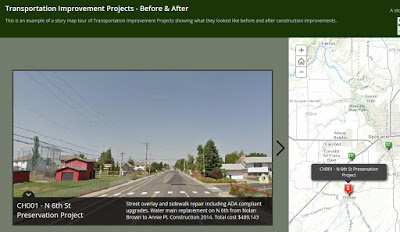
Now we’re expanding how we use online maps and creating new kinds of maps that
are less traditional and more visual. For instance, the Transportation Improvement Projects- Before
& After map uses photos to demonstrate how area roadways look before and after construction. It also includes
the location of each project, a description of it, when it was completed and
the project cost.
The Collisions 2009-2013 map is five maps in
one. You can choose which “layer” to view (or all five at once) including
collisions involving vehicles, bicycles or pedestrians, serious and fatal
collisions, or all collisions between 2009 and 2013, the five most recent years
of available data.
one. You can choose which “layer” to view (or all five at once) including
collisions involving vehicles, bicycles or pedestrians, serious and fatal
collisions, or all collisions between 2009 and 2013, the five most recent years
of available data.
 The Bridge Condition map shows
bridges throughout Spokane County that are either structurally deficient (require
repair or replacement of components such as cracked or broken concrete, or
potentially the entire bridge) or functionally obsolete (the design of the
bridge is not suitable for its current use and not able to handle traffic
volumes, speeds, size or weight of today’s vehicles).
Other new maps include an overview of the Congestion Management Process (CMP) and
the corridors studied in the CMP document, a review of “urban corridors” included in the Horizon
2040 long range transportation plan, and a map of SRTC’s Planning Boundaries and partner agency’s areas of operation.
the corridors studied in the CMP document, a review of “urban corridors” included in the Horizon
2040 long range transportation plan, and a map of SRTC’s Planning Boundaries and partner agency’s areas of operation.
To check out all the new maps, and
existing ones, go to the SRTC ArcGIS Online home page at https://srtc.maps.arcgis.com/home/index.html.
existing ones, go to the SRTC ArcGIS Online home page at https://srtc.maps.arcgis.com/home/index.html.