 |
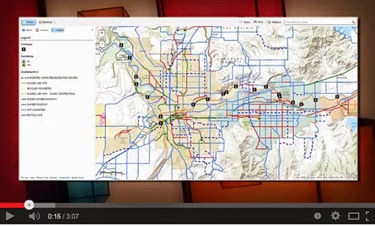
| The Bike Map in all it’s glory |
A reminder about two things; 1.) being summer, there is lots of road construction happening and 2.) being summer, it’s a great time to ride your bike instead of driving your car. This also helps you to get around construction projects easier. Or you can check the 2014 Spokane Regional Road Construction map. But if you choose to ride instead, there’s the 2014 Spokane Regional Bike Map to help navigate all of Spokane County via bike, no matter your skill level on two wheels.
So the whole point of this post was to remind you that we have two new “interactive” maps online for your use; the Bike Map and Construction Map, both which can be found at https://srtc.maps.arcgis.com/home/index.html. On both maps, you can pan and zoom to different areas, such as your neighborhood or route to work, to see what your bicycling options are in that area or what construction projects are scheduled.
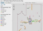 |
| You can zoom in to see more detail on the construction map |
Each local jurisdiction provided updated information on bicycling facilities and road construction in their area to increase public awareness about what’s happening with our transportation system. On both maps, you can click on a bicycle facility or construction project to learn more about it. On the Construction Map, clicking on a project location will give you the details of the project, including the exact location, approximate dates of construction and a direct link to that project’s web page or the agency’s construction page.
On the Bike Map, you can click on points such as trailheads, park and ride lots and bike shops. This will tell you what amenities each offers, such as restrooms, parking and bike lockers. You can also visit websites for area bike shops by clicking the shop location.
Firefox, Safari, Chrome and the latest versions of Internet Explorer and mobile browsers on all types of devices work best with ArcGIS Online.