 At SRTC, we keep track of traffic fatalities and serious injury accidents within Spokane County. And we put them on maps so you, and our planning staff, can see what areas need safety improvements. On a much larger scale, a map of every single traffic fatality in the U.S. between 2004 and 2013 has recently been released.
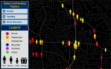
Zoom in to our area and you can see information such if alcohol or speeding were a factor in collisions and information on the victims, such as the sex of the person killed, if they were the driver, a passenger, pedestrian, etc.
If you want to get really close to home, entering your address in the search bar to see fatal collisions in your direct neighborhood.
The developer of the map says that 58% percent of the collisions on the map were caused by either alcohol,
speeding, or driver distractions; speeding in particular.